Hendrickson Marsh: water and wildlife
Hendrickson Marsh is more than just the water of its wetland basin. It has a combination of uplands or grasses and several food plots planted specifically for wildlife use each fall and winter.
The 8,000 acre watershed is what contributes runoff water to feed into the basin. The area is managed by the Iowa DNR Wildlife Bureau, with offices located at the Boone Research Station at Ledges State Park. Joshua Gansen is the wildlife management biologist who oversees this area and many other wildlife sites in central Iowa.
Hendrickson Marsh is not a huge wetland complex compared to other state owned sites in north central Iowa. However, it is an important ‘stepping stone’ each spring and fall when migrations of shorebirds and waterfowl take on new emphasis. It is a matter of timing for these migrating birds to find stop over sites to rest and feed before continuing on with their journey.
This 851 acre area is owned by the State of Iowa. It is located in the far southeast corner of Story County and a tiny portion of the southwest corner of Marshall County. This landform site has its geological origins born as the result of the last glacial maximum, the Wisconsinan system, in which a lobe of the Wisconsinan glacier penetrated into north central Iowa.
At the eastern edge of this glacial ice, the lateral moraine, a large segment of an ice block separated from the glacier during its retreat (melting phase) about 15,000 years ago. On the inset map, look for the small dot located next to what is today Hendrickson Marsh.
This block of ice full of rocks, silts, soils, and ground up glacial till pre-soil mixtures, was left stranded and away from the rest of the retreating glacial ice. It was not separate, however, from the outflow of melt water from the glacier and from the ice block itself.
What geologists theorize happened is that this big block of ice was left stranded to just sit there and melt in place. As it melted, all kinds of debris came out of the ice to surround it and in this process left a ring of parent material soils surrounding the ice block.
Eventually when all the ice melted, a shallow depression remained with lots of shallow standing water in place. Over long periods of time, a natural outlet was found by the water. That eventually joined and became what we now know as Clear Creek.
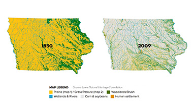
A bit more about the PPR — Prairie Pothole Region — is in order. It covers a vast area of southern Canada, segments of Montana, North and South Dakota, western Minnesota and north central Iowa. Many shallow wetlands are a signature of this landscape.
Some are ephemeral wetlands, and others are small to medium sized lakes. These lands also have a glacial history of deposits of soils that grew prairie grasses within its deep, rich soils, the basis for some of the most productive agriculture lands of North America.
During years of abundant rainfall, many of these former wetland depressions in the landscape refill with temporary and in some cases permanent water. If that happens during waterfowl migrations, the stage is set for many wetland sites that wildlife can use.
Hendrickson Marsh is a management challenge. Its large watershed can and does contribute abundant water if big enough rain events happen. The flip side of this coin are drought-like drier years.
Biologists attempt to hold water at various levels by control of the gate openings at the control structure and dam. If the idea is to lower the water within the basin to allow aquatic and emergent vegetation to grow, a lack of rain or too much rain can spoil the plans of managers.
But sometimes the rain event and good timing coincide to offer the right mix of water levels. Fall waterfowl hunters look for those opportunities in which just enough water remains for use of duck boats, and the water is still shallow enough to have allowed emergent vegetation to grow that serves as food for ducks and geese.
Hendrickson Marsh was purchased by the State of Iowa (Conservation Commission) in the mid-1960s. Prior to its acquisition, the area was locally known as Kimberly Marsh. Its natural wetland habitats brought hunters to the area.
Once bought by the state, a design for a dam and water control gate system was made, and construction was finished in 1968. The area got its new official name because of George Hendrickson, a professor of wildlife management at Iowa State University. A dedication ceremony was held on June 13, 1970, to give the area the official name of Hendrickson Marsh.
Plans for an improved water gate and drawdown apparatus have been on file for several decades. Due to funding issues, those updates have never been put to bid. If these improvements were to be made, water levels at Hendrickson could be better managed with draw down capability from the top down rather than from the bottom up.
Those large metal gates now in place, if opened, take water out the bottom, an undesirable situation, which also allows rough fish to enter the basin. Rough fish can be a huge problem as they disturb the lake bottom as they feed, creating turbid water, which in turn does not allow sunlight to penetrate.
Rough fish make for poor water quality issues. Natural drought conditions sometimes play into the hands of managers with low to very little water, killing off unwanted fish populations. One thing about wetland complexes is that there will be years of too much rain — just the right amount or too little. Those natural cycles have to be contended with year after year.
During this summer, if one is willing, a kayak or canoe adventure can be made to happen at Hendrickson. An excellent boat ramp and parking area are located southwest of the county line bridge on Arney Avenue.
From Rhodes, go west on county road E-63 for two miles, then turn north onto Arney Ave for about a half mile. The parking area will be on the west side of this county line road. Explore and enjoy.
——
Summer season is here, having arrived a few days ago on June 21. Long day lengths mark this time as our earth’s northern hemisphere is tilted toward the sun. This allows maximum and more direct sunlight radiation to penetrate the atmosphere.
Just the opposite is happening in the southern hemisphere, but it is our summer season when maximum photosynthesis takes place by all kinds of plant life. Those plants are using carbon dioxide to live and prosper, and they give off oxygen back to the air mix we breathe.
Our longest days were from June 18-24 at 15 hours and 15 minutes. From now on until December 21, day length will gradually get shorter, a fact I am sure you are already aware of. As one travels northward in the northern hemisphere, maximum day lengths are longer and longer until one arrives at the Arctic Circle, a point on the curvature of the earth where the sun never sets below the horizon but only touches it briefly. Our friends living and working in Fairbanks, AK, had a June 21 day length of 22 hours and 2 minutes.
Sunrise was at 2:53 a.m., and sunset was 55 minutes after midnight. Reading a book or newspaper outside at midnight in Fairbanks is a common thing.
For us earthlings, summer is picnic time, outdoor adventure time, state fair time, camping or fishing time and time for visits to swimming pools in local communities. Summer’s warmth is the opposite of blustery cold and snowy winter conditions.
So while summer is here, adapt to it, enjoy it and relax. Go on vacation to any of the four corners of Iowa to learn what Mother Nature has to offer. Remember to save a campfire cooked hot dog for fido the dog.
——
Garry Brandenburg is the retired director of the Marshall County Conservation Board. He is a graduate of Iowa State University with a BS degree in Fish & Wildlife Biology.
Contact him at:
P.O. Box 96
Albion, IA 50005
-

- PHOTOS BY GARRY BRANDENBURG — Hendrickson Marsh is a 851 acre area, mostly uplands, and of course the water body itself, when full, of about 250 surface acres. It is shallow water, but still, it is an attractive element for all kinds of migrating birds each spring and fall. In the meantime, lots of fur bearing animals call Hendrickson home. Examples are beaver, muskrat, mink, raccoon, weasels, skunks and lots of small rodents. Native reptiles and amphibians add to the wildlife mix. There are many resident waterfowl, wood ducks and others that nest in the grasses of the uplands. Its watershed that provides water is about 8,000 acres. Today’s image is looking from the northwest to southeast. The small insert map illustrates the defined area of North America called Prairie Pothole Region (PPR) country.