Canoeing the Iowa River — Tips for novices

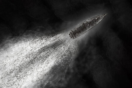
PHOTO BY GARRY BRANDENBURG — The Iowa River’s low flow assisted clean up crews last weekend to help find and remove litter from the water and stream bed. The list of items removed was extensive — and unfortunately, not too surprising. A river may hide lots of things that people may dispose of, “out of sight, out of mind.” But those things are still there, negatively impacting the environment and what others may see during a leisurely canoe/kayak float trip. Responsible river recreationists pick up after themselves. In today’s image, I happened to be conducting an airplane ride for family members on July 10th when we spotted lots of canoes near a sandbar south of Albion. It was a portion of the cleanup crew in action. Thank you to Iowa Project AWARE for their great effort.
As an avid canoeist, I have traveled the Iowa River from time-to-time, marveling at the quietness of the day, enjoying the breezes washing across the water’s surface, and listening to birds chattering somewhere in the shady tree lined shore.
A canoe trip allows one to get your mind off work. It allows one to think clearly. And canoe time allows one to be a kid again as flat rocks are found to skip across the water. Or canoe time also allows people to find artifacts, or clam shells, see fish occasionally. Canoes or kayaks means spending quality time In the company of good friends and/or family.
A short water voyage can be a perfect summer time activity outside. It sure beats being stuck inside a house.
For novice canoe paddlers, here are a few tips to help you on a summer river outing. First, do not attempt to paddle too far, assuming you are fit enough at paddle all day in order to arrive at a designated take-out point. This is an easy mistake to make. Do ask for advice from conservation staff members before you go. Do a short river segment so that you are not completely exhausted before your take-out point is reached. A short river segment would start from the Marshall County Forest Reserve boat ramp and go downstream for a take out at Timmons Grove County Park. That distance is 5.9 miles. And it is a half-day type river excursion. Keep it short and keep it fun. It will be a good test of whether you want to take on a 10, 12 or 15 mile long river journey at a future time.
Regarding water level and flow rates of the river, do ask ahead of time about water levels, or go the the US Corps of Engineers web site to look at river stages and flow rate data. In general for the Iowa River in Marshall County, a river stage of 10 to 11 is best for kayaks and canoes. This level equates to about one foot of water over sand bars (11′) to lots of sand bars exposed (10′) and ankle deep water in many places. Canoe paddlers soon learn to look for the darker water to ensure there is enough water to float the craft. And dark water also tells you where your canoe paddle can get enough bite to make for effective power strokes. It is inevitable that the river water will not always allow you to escape shallow water over sand. Then you will have to get out and drag the canoe toward deeper water.
The numbers I have given, as 10′ or 11′, are just relative numbers based on the river gage station at highway 14 river bridge. These numbers are not the depth of the water. Those numbers are used as a way of data gathering for hydrologists and engineers to know how much water the river is carrying at any particular time. Very low flow times, as in now, are related to the numbers 10 and 11 as I gave them to you. Actual base ‘gage zero’ is equal to an elevation above sea level of 853.10 feet. Flow rates now are under 250 cubic feet per second, a very low figure.
Any time you are on the water in a kayak/canoe or other water craft, be aware that safety is always a concern. Wear a life jacket. It is almost impossible put on a life jacket after a person falls overboard.
During the struggle to do so, bad things can happen. Water does not discriminate.
——–
More moderate river stages of say 12 or 13 mean there is more depth to the water — and faster flow rates for sure. The power of flowing water is very subtle and gets stronger as the river water depth increases.
High water is NOT the time to go canoeing for safety reasons. And when the river is at a moderate to high flood stage, these water conditions are a killer just waiting for you to make any mistake. Fast flowing flood water does not discriminate and it has the potential to take you down and never let you breathe air again. So it is important to ask questions of the conservation folks about safe river water levels before you venture out.
As a bit of history, the Iowa River’s record flood data from July 2, 2014 paints of picture of too much rain over too short a period of time.
The entire watershed was drenched with rains after rain event. The soils within the watershed were filled to capacity and could not absorb any more water. Therefore there was an almost instantaneous runoff of surface waters into every waterway, small and medium sized creeks, and ultimately to the Iowa River. River levels increased and kept increasing until the river finally crested at Marshalltown at a gauge reading of 22.25 feet. That elevation peak was registered at 875.35 feet. Subtract 853.10 from 875.35 to know how deep the actual river water was on that July 2014 day. As for flow rate, at peak flood time, there was over 23,900 cubic feet per second going downstream! That is a very dangerous situation. Just about every roadway into or out of Marshalltown was flooded. Road closures were everywhere.
We are currently in moderate drought conditions. We have had some rains to help disguise the effects of drought. A low flowing river is just one sign of not enough rain events. Yet hot summer time conditions does make a low flowing river an expected thing. Iowa’s long term climate has a history of highs and lows, hot and cold, snows or not much snow, and too much rain and not enough rain. Through all of these conditions, people do not have the power to turn on or turn off those climatic conditions set by the sun and other galactic natural forces of nature.
If we take a good hard look at science data, and geologic data of past climate patterns and natural climate shifts, a bigger picture emerges of the true huge driving forces of how nature controls our earth’s environment. There are no computer models that even come close to being accurate in trying to decipher past long term geologic climate shifts, let alone trying to predict what the future holds. However, rock strata of earth’s crust do tell stories of past environments, like tectonic plate movements, volcanoes, mountain building and mountain erosion, glacial events coming and going, ocean levels naturally changing in stride with glacial maximums and minimums.
And way too many present day news outlets are way to quick to jump on the band wagon of political correctness to point fingers at so called man-made climate change as the culprit. Those talking heads are lying to us, using fear as a tool to scare many people. So instead, a lot of folks are seeking out good unbiased science sources to find the facts, and learn the truth, so we can be better prepared to make rational judgments. Truth matters. And also remember there are no simple solutions to complex problems.
For instance, you may not know that the earth’s orbit around the sun varies from almost circular to slightly elliptical. This orbit shape changes back and forth every 100,000 years. So it takes 200,000 years for one cycle to happen. Solar radiation arriving at the earth can vary by a tiny percentage point, but it makes a difference. Now add earth’s axial tilt into the mix with a range from 21.5 degrees to 24.5 degrees.
This angle change is on a cycle of about 40,000 years. Then another factor, called precession, or wobble of the axis of earth, has its own 19,000 year cycle, and we learn that these ingredients of cosmic origin combine in subtle ways to create cycles of climates with a profound effect on long term climate shifts on earth. The sun, our little star, just one of millions in the Milky Way galaxy, sets the stage for hemispheric cold times with glacial buildups and advances, followed by warmer inter-glacial times with glacial retreats. We are blessed to be living in a present day inter-glacial warm time phase of earth history where agriculture can thrive. The alternative would not be pleasant for human kind.
——–
Monday, July 17, is a bird identification program at the Grimes Farm and Conservation Center. The time will be from 11:30 until about 12:30. Bring your own binoculars and bird ID devices or bird book. This is a free program. Naturalist Intern Bill Carey will lead a hike on the trails near the Center. Come enjoy a day outdoors where Mother Nature helps tell her stories.
——–
July 26, Kayaking at Green Castle will be the hands on program from 5:30 to 7:00 pm. This is a free program. Do call the conservation office at 641-752-5490 to register. The program will work on basics of kayaks and how to be safe on the water when recreating.
——–
Garry Brandenburg is the retired director of the Marshall County Conservation Board. He is a graduate of Iowa State University with a BS degree in Fish & Wildlife Biology.
Columnists
Real-world learning: How AEA partnerships are bridging the gap from classroom to career
What if finding a place in the workforce wasn’t overwhelming, but an opportunity discovered while working on a ...
There’s a buzz over an unusual constitutional standoff in Nebraska
Because of his intimidating style, the legendary 1950s baseball pitcher Sal Maglie was known as “The Barber.” ...
The U.S. must end its illegal boat strikes
This primary election, honor a veteran with your vote
Iowa has a deep history of military service. Hundreds of thousands of brave men and women have donned the uniform ...

Rob Sand is Iowa’s good neighbor