Conservation lands as the eagle may see them
Happy LABOR DAY WEEKEND. I trust you will be making the most of a long weekend as the end of summer nears.
If you are fortunate enough to have three days off from work, how will you spend that time? There are lots of ways of course, and each person may have a special task or two, a great family gathering, or maybe just relaxing in the shade of a tree at Sand Lake. Natural areas always beg for my attention, and that begging does not have to work too hard for outdoor enthusiasts who never get enough of the sights and sounds of nature as offered at conservation areas.
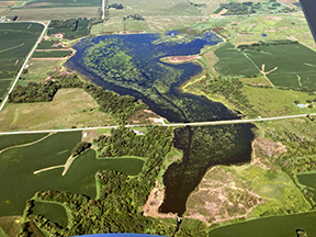
SAND LAKE is my first bit of informational item for you this weekend. I have written about this popular fishing area previously so a bit or repeated data is still in order.
Having a fishing body of water so close to Marshalltown allows for a quick getaway to wet a fishing line for a walleye, bass or crappie. Hiking is a popular activity along the levies and to explore the northern connection to the Iowa River. Wildlife sightings are always presenting new opportunities as fall migrations of waterfowl begin.
The original acquisition of Sand Lake took place in 1999. The deed showed 95 acres total of which approximately �…” was water and �…” as floodplain forest.
Within the last two years, another segment of land and water was added to Sand Lake because Martin-Martietta Company had run out of materials to mine and moved to a new site. The addition to Sand Lake added 98 acres for a new grand total of 193.
Like the original purchase, it is made up of about �…” water and �…” land. Fishing by electric or paddle powered boats now can allow people to seek out fish on about 130 acres of water.
Fish species known to live in Sand Lake are many river type species including catfish, bass, bluegill, walleye and a host of others. Add rainbow trout to the list due to stocking of these cold water species by Iowa DNR fisheries staff each spring and fall.
The Manchester, Iowa fish hatchery is the source for trout. By bringing trout to the people in places similar to Sand Lake, people will get a chance to catch new species.
Of course, the trout fee on one’s fishing license is required to possess trout. Like anything worthy of the effort, it takes time and money for the DNR to raise these fish to stocking sizes. In these cases, it is truly a user pays the way type of thing.
On March 28, 2023, high water flow rates in the Iowa River finally caused enough bank erosion along the north boundary near the northeast pool of Sand Lake to break the old land bridge. The northeast pool became connected to the Iowa River and vice-versa.
That watery connection now allows fish from the river to actively intermingle and move to and from the old gravel pool. It is in this pool last spring when a run of gizzard shad fish died in icy waters.
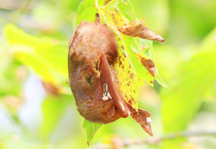
During a short interval of spring warm weather in 2025, over 30 bald eagles used the pool as a fishing bonanza opportunity. It was a short but exciting wildlife viewing opportunity.
Each of the excavated pools of water at Sand Lake are the result of sand and gravel extractions. A dredge pumped out sediments as deep as they could go and still obtain quality mining products.
On average, each pool has a maximum depth of 30 to 35 feet. Another fact of deep waters of old gravel pits, is the thermocline that develops each summer.
This is a layered effect of the top 10 feet of Sand Lake waters having sunlight penetration and enough dissolved oxygen for fish. Below the thermocline, water temperature changes and is almost devoid of oxygen. No oxygen and therefore no fish can live deep.
DNR fisheries staff in the early 2000s used a powerful boat to pull large trees toward the shorelines of the north pool. The trees were weighted down with a large amount of concrete blocks.
Each submerged tree offered habitat for fish in the oxygen favorable top layer of water. Those folks who fish from the shore have easy casting into and over the underwater habitat.
If one is in a boat, casting toward shore also works. Hunting is not allowed at Sand Lake.
——–
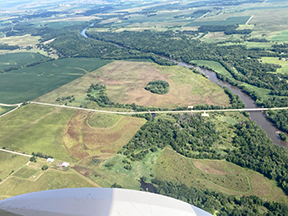
The STANLEY MILL MITIGATION AREA is west of Albion. There are 319 acres in this tract of bottomland/floodplain adjacent to the Iowa River.
It was acquired in cooperation with the Iowa Department of Transportation in the fall of 2018. Iowa’s DOT bought the land as their requirement to mitigate land changes due to Highway 30 corridor work mostly in Tama County.
Mitigation is an attempt to replace what may have been lost due to the road project. It is a complicated formula, but in the end, Iowa sportsmen and women have a big area to hunt game birds or game animals.
The name Stanley Mill comes from the nearby site of an old pioneer grain grinding mill that once operated on the former river channel. A low head dam was built to provide water power to the mill wheels.
Farmers could take raw grain to the mill to process it so as better feed for livestock. The county gravel roadway was also named Stanley Mill Road.
Mitigation work involved creating shallow and ephemeral wetlands, planting lots of trees in selected areas, and seeding most of the area lands to native prairie. The trees and the prairie grasses are looking very good.
Specifically, 4,522 trees were planted with silver maple, river birch, shagbark hickory, walnut, sycamore, eastern cottonwood, swamp white oak, bur oak and American elm. Shrub count was 1,215 of silky dogwood, elderberry and buttonbush.
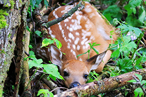
Habitat is what these trees, shrubs and grasses helped make. Pheasants, wild turkey and deer utilize the area. Hunters will have their work laid out for them when pursuing game at this site.
Management of this area is now a function of the staff of the Marshall County Conservation Board. Public hunting is allowed.
——–
A state DNR area is the last aerial image to be depicted today. It is named after the late professor of wildlife at Iowa State University, George Hendrickson.
There are 851 acres of uplands and of course the basin containing shallow water of the marsh. The area was acquired by the State Conservation Commission, now called the Department of Natural Resources, in the mid 1960s. A dam and water control structure was built on the Marshall County side in 1968.
Most of the basin containing water is in Story County. About 8,000 acres of watershed contributes water to the site.
The basin itself was formed during past geologic times when a large ice block melted off of the retreating Wisconsinan glacier. The timeframe was probably about 18,000 years ago, plus or minus.
Glacial ice over most of what was to become north central Iowa had advanced as far as where Des Moines is now. As a naturally warming climate caused the glacier to begin melting back, its water runoff created many changes to the landscape, carving river valleys and supplying water eastward to what would become the Skunk River watershed and many others.
A very large block of glacial ice filled with frozen soil, rocks and debris was calved off the glacier’s east edge. It sat in one place and melted away. That location is now the site of Hendrickson Marsh.
Like many other wetlands, it is used by migrating waterfowl and shorebirds every spring and fall. As we approach the fall of 2025, Hendrickson’s water will attract lots of ducks, geese and numerous songbirds, shorebirds and birds of prey.
Upland habitat is in place for pheasants. Deer use the area also. Songbirds will utilize water and land as a feeding area and rest area for migration needs.
This area is open for public hunting.
——–
This weekend is the beginning of some hunting seasons with cottontail rabbits and squirrels. Rabbit season starts Aug. 30 and goes through Feb. 28, 2026.
The daily limit is 10, and possession limit is 20. For squirrels, the start date is Aug. 30 and goes until Jan. 31, 2026.
A new publication of DNR rules and regulations is available. Acquire a copy at any outdoor store or place where hunting licenses are sold.
Some of the major seasons coming up will be youth waterfowl on Sept. 20-21 north zone, Sept. 27-28 central zone and Oct. 4-5 South zone. Page nine of the booklet has the details for waterfowl starts for ducks or geese.
Early migrating ducks like teal have a season from Sept. 6-14. Dove season begins Sept. 1, snipe and rails Sept. 6.
Youth pheasant season has an Oct. 18-19 date. For the regular opener for pheasants, it is Oct. 25.
As per normal, shooting times begin at 8 a.m. and end each day at 4:30 p.m. Pheasant hunting in Marshall County can take place on public lands of Arney Bend, Stanley Mill, Marietta Sand Prairie, Mann Wetlands Wildlife Management Area, Iowa River Wildlife Area and the Klauenberg Prairie Preserve.
Do secure permission for hunting on private lands.
——–
Garry Brandenburg is the retired director of the Marshall County Conservation Board. He is a graduate of Iowa State University with a BS degree in Fish & Wildlife Biology.
-
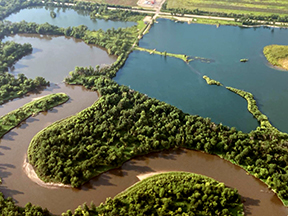
- PHOTOS BY GARRY BRANDENBURG — Some good flying weather recently allowed for making images of many conservation areas. Just three images were selected for your perusal this weekend. They are Sand Lake located east of Marshalltown, Hendrickson Marsh on the Story/Marshall County line about 2 miles west of Rhodes, and the Stanley Mill Mitigation Area, a wildlife and prairie reconstruction site located two miles west of Albion. Conservation lands serve many purposes although the needs for wildlife in the form of good habitat tops the list. Upland game birds, furbearers, lots of migrating birds, and deer occupy discrete portions of all these lands. Even Sand Lake, with its primary draw for people of fishing in the former Martin-Marietta sand and gravel quarry, has some small forest segments along the north edge that provide woodland habitats.