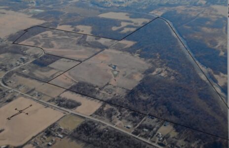
An eagle’s eye view of the land
To see what an eagle sees sometimes requires a method of becoming airborne just like the big predatory bird. Us humans have to resort to aircraft to do so.
Flying offers the opportunity to view the land below from an entirely new perspective. Things we are familiar with from ground level look different only because you or I can now look down on the entirety to gain a big picture view.
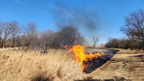
In today’s large image of the Iowa River Wildlife Area (IRWA), the Sand Road is a prominent feature near the bottom portion of the photo. The Iowa River forms the western boundary and its braided exposed sandbars are easily recognized.
The Iowa Veterans Home is near the top center. The North Center Street river bridge can be found in the upper left portion of the frame.
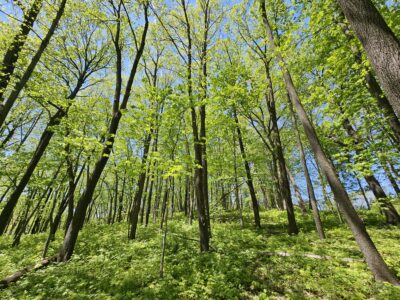
Natural vegetative cover on the IRWA consists of about one-third grassland, of which some has been restored to native grasses and native prairie flowers. The other two-thirds are forested lands.
These forests occupy both floodplain low lying flat lands and a significant area of hilly bluff lands. This large parcel came about in phases — one being the purchase of 330 acres, with critical support and time from the Iowa Natural Heritage Foundation.
Another phase that came about during the same time frame was a cooperative venture with the Iowa Department of Transportation. They acquired 155 acres as a mitigation site in which they were required to offset Highway 30 improvement work in Marshall and Tama County.
From a public point of view, it is all one big landscape wide parcel now dedicated to wildlife conservation. A more recent donation of 26.8 acres from a private family brings the total acreage to 492.9 acres.
Wildlife species that can be found in this area are many. Ground nesting birds such as the Dickcissel, Meadowlark, Bobolink, Pheasant and Wild Turkey are just a few. In the forested areas, one may find Bald Eagles, Red-shouldered hawks and Great Blue Herons along with many others.
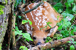
Typical species of critters include deer, raccoon, mink, otter, squirrels, woodchucks, coyotes. Small mammals are abundant in the grasslands, along with amphibians and reptiles in pond areas and wetland sites.
The bluff lands have an interesting natural history. The bluffs are rich in sandy soils, all a product of centuries of wind action. It started many thousands of years ago when horrific winds swept off the Wisconsinan glacial landscapes lying in north-central Iowa, and specifically the Story and Hardin County areas of today.
Back then, when the last glacial maximum had come to a halt, ice margins melted back northward. Exposed glacial till soils were easily eroded by gale force winds. The winds picked up and sorted loose material.
Sand grain sized particles were suspended in these fast moving winds. However, as those winds came into contact with the bluff, the winds were forced up and in so doing, lost speed and the ability to hold sand in suspension.
Sand grains fell to the ground, just like snow on the lee side of a snow fence. Over thousands of years, the sand accumulated to great depths.
The sandy soils of the bluff, and also well mixed into the area’s grassland soils, works like a big sponge. These sandy soils hold water and allow the water to slowly seep out along the bluff base.
These springs run continually from the bluff’s underlying water table. Sand is so pervasive in the surrounding sections of land that it becomes a fixture of how most of the private lands have to be cautiously managed to prevent erosion. The reason the Sand Road is called the Sand Road is due entirely to its geologic age source material.
A quick word about the Iowa River. As seen in today’s image, it looks like a straight channel. It is straight now because it was channelized by a floating dredge in the early 1920s. In this segment of the river, surveyors had cleared a once timbered pathway between Albion and the Iowa Soldiers Home, as it was called then.
The looping and very curving natural meandering courses of the former Iowa River channel were cut off. Remnants of the old river’s channels are still evident in the floodplain if one knows what to look for when hiking in this area. They still fill with water during flood times, or after sufficient normal rainfall events.
This winter, or any season for that matter, is a good time to get outside to get some exercise and go exploring. Obtain a brochure and map of the Iowa River Wildlife Area at the Grimes Farm and Conservation Center.
Then venture to the IRWA, grab your backpack, walking stick, and camera for a voyage onto one of the best natural areas in Marshall County. Enjoy getting to know more about this outstanding public parcel of land.
———-
Motus is the name assigned to a network of automated radio telemetry stations that allows researchers to monitor/track numerous species of birds, bats or insects. A Motus tower has been installed at Albion City Hall to serve in this wildlife research project. The cost has been
entirely covered by private donations in a cooperative venture with the Iowa DNR and the Marshall County Conservation Board.
The Motus Wildlife Tracking System is an international collaborative network of researchers. Automated radio signals of a migrating critter will set off a signal to any nearby monitoring station anywhere in the world.
Data is instantly available to researchers, educators, organizations and citizens. Tracking of even some small insects is possible over very long distances. Very tiny electronic tags are attached to the animal.
From that time forward, the animal does not have to be recaptured to know where it is. These special tags are registered and the data is processed by Motus. A small fee for registration enables the work on the ground to be maintained.
An example from last fall had a shorebird, a Greater Yellowleg, migrating from Canada southward, had its signal picked up in North Dakota, then northern Iowa, and southeast Iowa and into the Carolinas.
This migration took only three days! The bird averaged over 85 miles per hour on its incredible journey. Over time, there will be other fascinating migration stories to be told by this citizen science supported project. Stay tuned.
———-
Another wildlife management project is underway. It involves Iowa white-tailed deer and deer hunters. As of mid week, Iowa deer hunters had registered over 99,700 animals taken by hunters.
Those seasons that began with youth seasons last fall, and then with early muzzleloaders and archers, followed by shotgun seasons one and two, are now in the final stages. Regular deer seasons end Jan. 10. There will likely be a few special late January seasons in specific areas where special extra effort is needed to reduce doe deer numbers. Stay tuned.
———-
A deer antler measuring program has been set for Wednesday, Feb. 22 at the Grimes Farm Conservation Center. Time is in the evening from 5:30 to 7:30 p.m. Do pre-register by Feb 17. for a limited amount of spaces.
Call 641-752-5490 or email mccb@marshallcountyia.gov. Deer antlers to be scored could be from the recent season or an old mount that people are just curious about.
Another note to note: The Iowa Deer Classic in 2023 will be the weekend of March 3-5 at the Iowa Events Center in Des Moines. This is always a popular event where many thousands of people will pass through the doors to admire deer and deer hunting products, attend informative seminars, and see Iowa’s Big Buck contest entries.
———-
Congratulations To Emily Herring, naturalist with the Marshall County Conservation Board, who very shortly will take over the position of Director. May the best of luck be your fortune. Your leadership skills have already been proven. Local conservation efforts will continue under your vision. Welcome aboard.
———-
Garry Brandenburg is the retired director of the Marshall County Conservation Board. He is a graduate of Iowa State University with a BS degree in Fish & Wildlife Biology.
Contact him at:
P.O. Box 96
Albion, IA 50005
-
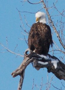
- PHOTOS BY GARRY BRANDENBURG — Eagles have fantastic vision to see things from high altitudes. Today’s aerial image may present a similar view an eagle might see as it soars stealthily over the landscape. This image was made by this author from an airplane on Nov. 25, 2022. However, at least three bald eagle nests are within or very close proximity to the public land as outlined in bold black lines. This is the Iowa River Wildlife Area, a 492.9 acre segment of natural lands adjacent to the Iowa River and its associated floodplain and bluff topography. Bald Eagles fly over all this territory regularly as they hunt for land prey and/or fish in the river.